Print booklet:1 2
Walking direction photo: 17 for walk Old Airfield, Tarrant Rushton, Dorset. Walk direction photograph: 18 for walk Old Airfield, Tarrant Rushton, Dorset, South West England.
Walking direction photo: 19 for walk Old Airfield, Tarrant Rushton, Dorset. Walk direction photograph: 20 for walk Old Airfield, Tarrant Rushton, Dorset, South West England.
Walking direction photo: 21 for walk Old Airfield, Tarrant Rushton, Dorset.
Previous © J. Ansell 2002-2009 Printing Hints
Print booklet:1 2

Tarrant Rushton

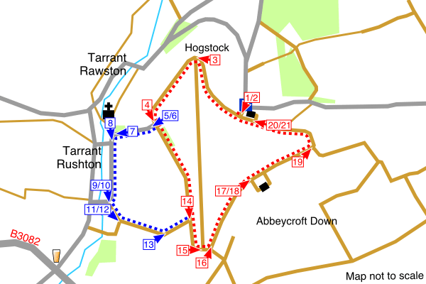
An easy walk around the perimeter road of the old airfield, which was built on a natural plateau in the Dorset countryside. It is often windswept. The walk can be extended through the village of Tarrant Rushton.

On the B3082 between Blandford Forum and Wimborne Minster, turn off towards Tarrant Rushton at the The True Lovers Knot pub. Drive past Tarrant Rushton and Tarrant Rawston then take the turning towards Witchampton. Park near the airfield memorial located at a sharp turn in the road.

Map:OS Landranger Sheet 195Grid Ref:ST 950 061

Old Airfield

Distance:3.4 miles / 5.4 kmClimb:130 feet / 40 m
Difficulty:EasyDate:July 2007

Old Airfield and Village

Distance:4.1 miles / 6.6 kmClimb:240 feet / 75 m
Difficulty:EasyDate:July 2007
Printing Hints © J. Ansell 2002-2009