 |
|
|
|
|
|
The Jurassic Coast - Rodney Legg |
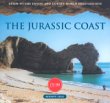 |
| The Jurassic coast of Devon and Dorset has joined the Grand Canyon and the Great barrier Reef as a World heritage site. It was the first natural landscape in Great Britain to win this highest of international accolades. It is described as Jurassic for its famous dinosaur-bearing strata but the visual geology extends either side of this period, across the mesozoic era from the triassic to the cretaceous. From Orcombe Point, Exmouth to Old Harry Rocks, Studland bay, this coast provides a walk in time through 180 million years in just 95 miles, plus fossils new to science which appear as it continues to erode. |
|
|
|
The Salisbury Hoard - Ian Stead |
 |
| A real-life story of archaeological detection, leading to a unique prehistoric hoard The Salisbury Hoard is the most remarkable hoard of prehistoric metalwork ever found in Britain, but knowledge of it was almost lost with artefacts scattered by metal-detectorists, dealers, auction houses and collectors. Thanks, however, to the dogged persistence of Dr Stead well over half the hoard has now been recovered and acquired by the British Museum, where it will be displayed as one of the most important finds of the century. Ian Stead's first-hand account has been widely hailed as one of the most riveting books on archaeology ever published with fantastic reviews of the hardback. These included: 'A rattling tale of skulduggery and scholarship which is almost too shocking to be true.' - 'Time Team' Book Club. 'A thriller of a book about the discovery, dispersal and recovery (or nearly) of one of the most important prehistoric hoards ever found.' - Prof. Martin Carver, British Museum Magazine. |
|
|
|
Landmark Visitors Guide: Dorset - R. Sale |
 |
| For the independent traveller to Dorset wishing to visit the coast and the countryside and also experience what the area really has to offer, the Landmark Visitors Guide: Dorset is the essential companion. Following a general introduction to the area, the book is structured in the form of guided itineraries covering all the popular places of interest, events and attractions together with many lesser known features. For ease of exploration the country is divided into seven areas. The routes take the reader through fascinating old cities, towns and villages and stunningly attractive scenery. |
|
|
|
Explorer OL15 Purbeck and South Dorset |
The Ordnance Survey Explorer Maps are specially designed for walkers, off-road cyclists, horse riders and all involved in outdoor activities. These maps show: camping and caravan sites, picnic areas and viewpoints, selected places of interest, rights of way information, National Trail and Recreational Path routes shown and selected tourist information. Scale: 2½ inches to 1 mile / 4 cm to 1 km. Includes: Poole, Weymouth, Dorchester, Bridport, Isle of Portland, Wareham |
|
|
|
Explorer OL22 New Forest |
The Ordnance Survey Explorer Maps are specially designed for walkers, off-road cyclists, horse riders and all involved in outdoor activities. These maps show: camping and caravan sites, picnic areas and viewpoints, selected places of interest, rights of way information, National Trail and Recreational Path routes shown and selected tourist information. Scale: 2½ inches to 1 mile / 4 cm to 1 km. Includes:Bournemouth, Southampton, Christchurch, Ringwood, Lymington, Eastleigh, Totton. |
|
|
|
Landranger Map 0183: Yeovil & Frome |
The Ordnance Survey Landranger Maps are ideal for planning great days out. They include the following information: tourist information, camping and caravan sites, picnic areas and viewpoints, selected places of interest and rights of way. Scale: 1¼ inches to 1 mile / 2 cm to 1 km. This map includes: Yeovil, Frome, Chewton Mendip, Radstock, Westbury, Wells, Shepton Mallet, Warminster, Glastonbury, Castle Cary, Mere, Bruton, Wincanton, Marston Magna, Shaftesbury, Sherborne & Stalbridge. |
|
|
|
Landranger Map 0184: Salisbury & The Plain, Amesbury |
The Ordnance Survey Landranger Maps are ideal for planning great days out. They include the following information: tourist information, camping and caravan sites, picnic areas and viewpoints, selected places of interest and rights of way. Scale: 1¼ inches to 1 mile / 2 cm to 1 km. This map includes: Salisbury, Amesbury, Edington, Market Lavington, Netheravon, Tidworth, Haytesbury, Shrewton, Hinden, Dinton, Ludwell, Broad Chalke, Whiteparish, Downton, Nomansland. |
|
|
|
Landranger Map 0185: Winchester & Basingstoke, Andover & Romsey |
The Ordnance Survey Landranger Maps are ideal for planning great days out. They include the following information: tourist information, camping and caravan sites, picnic areas and viewpoints, selected places of interest and rights of way. Scale: 1¼ inches to 1 mile / 2 cm to 1 km. This map includes: Winchester, Basingstoke, Andover, Romsey, Hurstbourne Tarrant, Whitchurch, Micheldever, Lasham, Stockbridge, New Alresford, Eastleigh & West Meon. |
|
|
|
Landranger Map 0193: Taunton & Lyme Regis, Chard and Bridport |
The Ordnance Survey Landranger Maps are ideal for planning great days out. They include the following information: tourist information, camping and caravan sites, picnic areas and viewpoints, selected places of interest and rights of way. Scale: 1¼ inches to 1 mile / 2 cm to 1 km. Includes: Taunton, Lyme Regis, Chard, Bridport, Somerton, Wellington, Ilminster, Crewkerne, Honiton,Axminster, Beaminster, Ottery St Mary, Kingston St Mary, Milverton, Stoke St Gregory, Curry Rivel, Corfe, Curry Mallet, South Petherton, Culmstock, Broadway, Dunkeswell, Yarcombe, Luppitt, Stockland, Tatworth, Membury, Northleigh, Bettiscombe, Colyton |
|
|
|
Landranger Map 0194: Dorchester and Weymouth, Cerne Abbas and Bere Regis |
The Ordnance Survey Landranger Maps are ideal for planning great days out. They include the following information: tourist information, camping and caravan sites, picnic areas and viewpoints, selected places of interest and rights of way. Scale: 1¼ inches to 1 mile / 2 cm to 1 km. This map includes: Dorchester, Weymouth, Cerne Abbas, Bere Regis, Blandford Forum, West Coker, Yetminster, Sturminster Newton, Corscombe, Melbury Osmond, Buckland Newton, Woolland, Milton Abbas, Maiden Newton, Piddlehinton, Milborne St Andrew, Puddletown, Uploders, Winterbourne Abbas, Stratton, Litton Cheney, Abbotsbury, Chickerell, Broadmayne, Osmington, Bovington Camp, Wool, West Lulworth. |
|
|
|
Landranger Map 0195: Bournemouth & Purbeck, Wimborne Minster & Ringwood |
The Ordnance Survey Landranger Maps are ideal for planning great days out. They include the following information: tourist information, camping and caravan sites, picnic areas and viewpoints, selected places of interest and rights of way. Scale: 1¼ inches to 1 mile / 2 cm to 1 km. This map includes: Bournemouth, Poole, Christchurch, Wimborne Minster, Ringwood, Wareham, Fordingbridge, Tarrant Hinton, Cranborne, Gussage All Saints, Verwood, North Gorley, Witchampton, Three Legged Cross, Burley, Ferndown, Bransgore, Sway, Lytchett Matravers, Corfe Mullen, Hurn, New Milton, Milford on Sea & Corfe Castle. |
|
|
|
Landranger Map 0196: The Solent & the Isle of Wight, Southampton & Portsmouth |
The Ordnance Survey Landranger Maps are ideal for planning great days out. They include the following information: tourist information, camping and caravan sites, picnic areas and viewpoints, selected places of interest and rights of way. Scale: 1¼ inches to 1 mile / 2 cm to 1 km. This map includes: Southampton, Portsmouth, Totton, Fareham, Gosport, Lymington, Ryde, Sandown, Shanklin, Ventnor, Cadnam, Lyndhurst, Hythe, Brockenhurst, Beaulieu, East Boldre, Botley, Hambledon, Wickham, Southwick, Warsash, Yarmouth, Shalfleet, Brighstone, Godshill, Blackgang, Bembridge |
|
|
|
|
|
|
|
|