| |
![](../../common/transpix.gif) |
![Click on view to enlarge.](s_images/area01.jpg) |
![Click on view to enlarge.](s_images/area02.jpg) |
![Click on view to enlarge.](s_images/area03.jpg) |
|
|
|
Click on view to enlarge. |
Worth Matravers, Dorset, South West England
|
![](../../common/transpix.gif) |
|
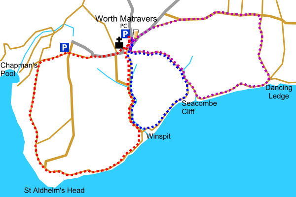
Worth Matravers is an attractive small village situated in the south of the Purbecks. It is an excellent starting point for a number of walks along the South West Coastal Path. The Square and Compass pub in Worth Matravers is a popular with walkers.
The 3 walks described in this area can be combined for a slightly longer walk, taking the route: Worth Matravers, Chapman's Pool, St Aldhelm's Head, Winspit, Seacombe, Dancing Ledge then back to Worth Matravers (via the Priest's Way). Total Distance: 7.9 miles / 12.7 km.
Worth Matravers is sign posted off the B3069 which joins the A351 Wareham to Swanage road. Park in the large car park to the north of the village.
![](../../common/transpix.gif) |
![](../../common/keys2/Parking.gif) |
Parking |
![](../../common/keys/Main_road.gif) |
Main road |
![](../../common/keys/Minor_road.gif) |
Minor road |
![](../../common/transpix.gif) |
![](../../common/keys/Track.gif) |
Track |
![](../../common/keys/Footpath.gif) |
Footpath |
![](../../common/keys/Stream.gif) |
Stream |
![](../../common/transpix.gif) |
![](../../common/keys2/Public_house.gif) |
Public house |
![](../../common/keys2/Church.gif) |
Church |
![](../../common/keys2/Public_convenience.gif) |
Public convenience |
![](../../common/transpix.gif) |
![](../../common/keys/Picture.gif) |
Picture |
|
|
|
|
|